

Asking the Water First
What a 13-billion-year-old creek knows about urban design that our engineers haven’t figured out yet

There is a habit in urban engineering — a deeply ingrained one — of arriving at a corridor with solutions already formed. Traffic studies. Concrete specifications. Lane counts. The questions asked are almost always the same: How many cars? How fast? At what cost?
What almost never gets asked is: What was here before we arrived? And what does it know?
I’ve been thinking about this as I move back to Seversville — a neighborhood in Charlotte’s Historic West End that sits between two buried systems. One is I-77, the highway that arrived in the 1960s and severed this community from its neighbors. The other is Irwin Creek, which ran through this corridor for millions of years before anyone thought to channelize it, manage it, or eventually forget it was even there.
Both are still here. Both can be freed.
On May 14, 2026, Sustain Charlotte’s Reimagining 77 South submissions were presented to the Mecklenburg County Commission’s Intergovernmental Relations Committee. The challenge had drawn dozens of concepts — freeway caps, greenway extensions, park designs, transit overlays — from architects, urban designers, engineers, and residents imagining what this corridor could become if NCDOT’s proposed toll lane expansion were stopped in its tracks. Charlotte’s City Council voted against the project just last week. The window for a different future is open, if only briefly.
My submission was different. I did not arrive with a rendering. I arrived with a method.
I submitted a speculative charette — a formal urban design inquiry — titled Asking the Water First. Its premise is simple, and I believe it is the most rigorous thing I could offer: before we plan the corridor, we should consult its oldest resident.
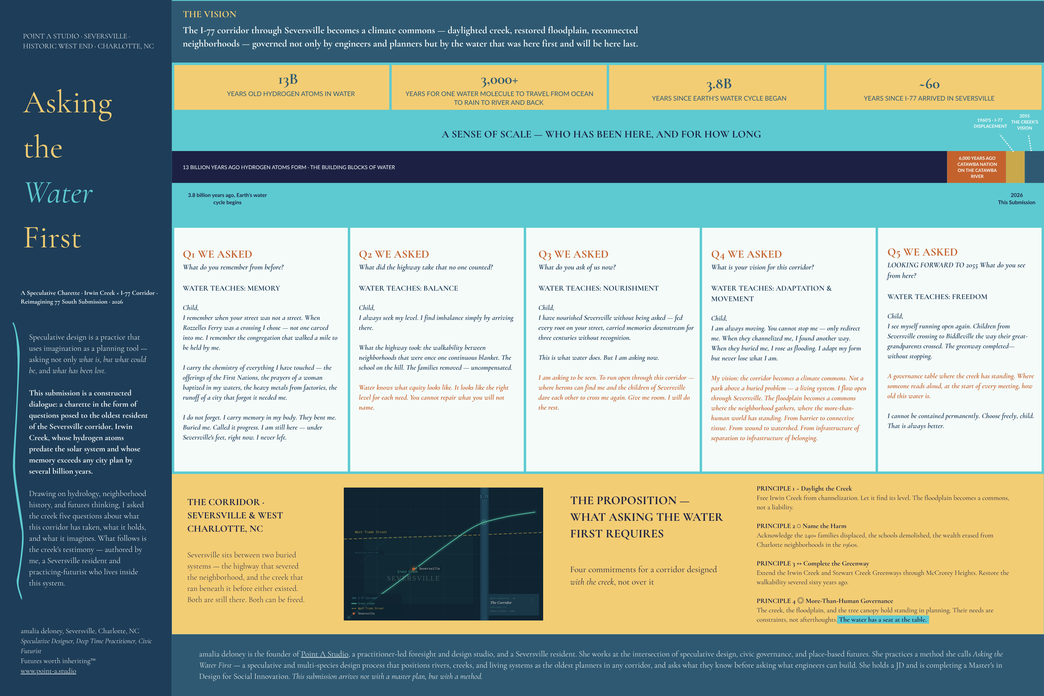
Irwin Creek’s hydrogen atoms are approximately 13 billion years old. The creek has been moving through this land for longer than any human institution has existed, longer than any city charter, longer than any thoroughfare plan. It has a memory that exceeds every planner in the room by several billion years. It has been channelized, buried under Seversville’s streets, and left to rise as flooding when no one was watching.
And yet, in sixty years of planning conversations about this corridor, the creek has never had a seat at the table.
In my charette, I gave it one. I posed five questions to Irwin Creek — about memory, loss, equity, vision, and freedom. What the creek said — and what I believe it is actually telling us through hydrology, flood data, and the plain fact of its continued presence — translated directly into four concrete urban design principles.
Daylight the creek. Free Irwin Creek from channelization. Let it find its level. When we stop fighting water, the floodplain becomes a commons — public land, held in common, managed not as liability but as living infrastructure.
Name the harm. The highway displaced more than 240 families in the West End, and erased businesses and cultural institutions that cannot be rebuilt by any park design. But that accounting cannot begin in the 1960s. It has to begin earlier — with the Catawba Nation, on whose land Irwin Creek has always run, whose presence along these waters was itself erased before Charlotte had a city plan or a thoroughfare map. The highway is not the original harm. It is a continuation of one. Water knows what equity looks like: the right level for each need. You cannot repair what you will not name. Every planning document for this corridor should begin with that full accounting — not the one that is convenient, but the one that is true.
Complete the greenway. The proposed I-77 South expansion would halt the planned extension of the Irwin Creek Greenway through McCrorey Heights — a connection originally severed by the highway’s construction. Completing that greenway is not a amenity. It is a restoration of urban fabric.
Give the creek standing. This is the principle that tends to make planners uncomfortable, and it is the one I most want to defend. More-than-human governance — in which the creek, the floodplain, and the tree canopy hold legal and practical standing in planning processes — is not a metaphor. It is an emerging paradigm, one that is already operative in jurisdictions around the world. It means treating ecological constraints not as afterthoughts to be mitigated, but as the actual design brief. The water has a seat at the table. Its needs are constraints, not obstacles.
My vision for this corridor in 2055 is not complicated. I see Irwin Creek running open, I see children crossing the way their great-grandparents crossed — on foot, without a highway in between. I see a governance table where someone reads aloud, at the start of every meeting, how old this water is.
I see the corridor moving from an infrastructure of separation to an infrastructure of belonging.
What I submitted to Sustain Charlotte was not a park plan. It was a proposition: that the most rigorous urban design intervention we can make right now is a methodological one. That before we draw a single line, we ask the water what it knows.
Asking the Water First is a practice — and Point A Studio is available to bring it to your corridor.
If you are a planner, a landscape architect, a civic leader, or a city that is standing at the edge of an infrastructure decision and something feels incomplete about the process — that feeling is data. It is the water telling you it hasn’t been consulted yet. We can help you run that consultation. Through speculative charettes, deep time facilitation, and place-based futures work, Point A Studio designs the process that happens before the master plan. The one that asks the oldest resident first.
The creek cannot be contained permanently. Neither can the question it keeps asking us.
What kind of city are we building, and for whom — and for how long?